Location: 
 SS36 Splugen to Chiavenna (25 miles)
Coordinates: 46.5056,9.33028
Ridden: 2010 & 2012
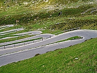 From the village of Splugen the pass is clearly signposted. The first stretch is a series of gentle hairpins, which lead you up to a long drag up the valley to an interminable series of very tight and sometimes blind hairpins. After an age the road opens up a little and you find yourself at the summit – unusual for a pass in that there isn’t the usual pass sign stating the height above sea level. The ascent from Splugen is only 6 miles at an average gradient of 6.4 %. From Chiavenna the climb is much longer – 19 miles at an average 5.9%. This is an old pass road designed before the advent of cars and motorbikes so it’s very tight in places with many parts in tunnels cut into the rock face – fine for a horse and cart but not so good if you’re on a bike and meet a car coming the other way. Past Pinazzo the road opens out and you have a fairly fast section up to the Lago di Montespluga. From the lake it’s a short climb to the summit.